
Canyons of the Ancients Visitor Center closed for repair work February 19 - 26

Uncompahgre Field Office Travel Management
A comprehensive travel and transportation management plan is a wide-ranging analysis considering the access needs of all public land users. Access needs are evaluated in conjunction with the BLM's legal mandate to protect natural and cultural resources on public lands. Individual route evaluations and designations included in the comprehensive travel and transportation management plan will be analyzed in an environmental assessment.
As stated in the Uncompahgre Field Office Resource Management Plan, the goal of travel and transportation management is to manage travel in the UFO to support the BLM’s mission, achieve resource management objectives, and provide appropriate, sustainable public and administrative access.
The UFO identified the objective of maintaining and improving land health while promoting responsible use through active travel management and within in each Travel Management Area, designating a comprehensive travel management system that achieves resource management objectives, provides appropriate, sustainable public and administrative access, communicates with the public about opportunities, and monitors the effects of use.
During land use planning, each UFO area received one of the following allocations:
- Open: Open to all modes of travel
- Limited: Travel is restricted in some form (seasonally, administrative access only, vehicle width, non-motorized use, etc.)
- Closed: Travel is closed to off-highway vehicle, mechanized, and/or cross-country use.
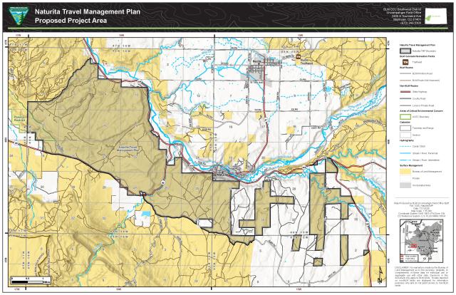
Naturita Travel Management Plan (TMP)
The BLM is seeking input to begin the TMP planning process for the Naturita Area Route Network. Public input will be accepted for 60 days from January 21 through March 18, 2025.
Comments during this initial phase should focus on:
- Missing routes
- Inaccuracies in data (misalignments)
- Information on use level and type on each route
- Staging areas and access
- General area uses, etc.
Members of the public are encouraged to submit their comments to the Uncompahgre Field Office recreation program email address at BLM_CO_UFO_Recreation@blm.gov or by USPS mail to the Uncompahgre Field Office, 2465 S Townsend Ave, Montrose, CO 81401, Attn: Caroline Kilbane.
Phases in the Naturita travel management planning process:
- Inventory Verification and Envisioning (current phase): This is the public's opportunity to review BLM's inventory data and provide feedback to verify and add context to that data. Comments during this phase should focus on: missing routes, inaccuracies in the data (misalignments), information on use level and type on each trail, staging areas and access, and general area uses, etc.
- Route Evaluation and Drafting of the Environmental Assessment: This phase of the process is internal to the BLM. The BLM will incorporate information from phase 1 into developing the alternatives.
- Public Comment Period: This is the public's opportunity to provide comments on the range of alternatives outlined in the Environmental Assessment (EA).
- Decision Release: This phase of the process is internal to the BLM, in which comments from phase three are incorporated into the final decision and the final decision is announced.
- Plan Implementation: This final phase is when on-the-ground projects can begin: Signs can be installed, maps and brochures can be created, and route repairs and reclamation can occur.
For more information about the Naturita TMP, contact the Uncompahgre Field Office at:
BLM Uncompahgre Field Office, 2465 S Townsend Ave Montrose, CO 81401. Attn: Naturita TMP
Phone: (970) 240-5300