
BLM recreation sites available to all: Exploring accessibility on California’s public lands
The EXPLORE Act, or the Expanding Public Lands Outdoor Recreation Experiences Act, is designed to improve access to outdoor spaces, including people with disabilities, veterans, and children. In support of that law, over the next year we will explore accessible public lands, state- by-state, managed by the Bureau of Land Management (BLM) on behalf of the American people.
This month, we’ll help you discover sites on California’s 15 million acres of public lands with accessible fishing, camping, picnicking, and scenic views in Northern California; accessible trails and virtual tours of a Central California wetland; a virtual tour of a lighthouse on the Central California coast; as well as a low sensory area and audio tour in Southern California.
Northern California
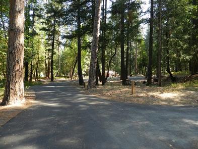
Douglas City Campground is 100 miles inland, off State Highway 299, and is open from May to October for world famous fly-fishing. The Redding Field Office manages this campground that offers 23 campsites along the Trinity River with varying levels of accessibility, including picnic tables with extended ends for people in wheelchairs, and accessible fire rings and bear boxes for bear-safe storage of camping supplies and food. The best feature, besides the river, of course, is that after a fun day outside, you can use the accessible showers and make use of the flush toilets!
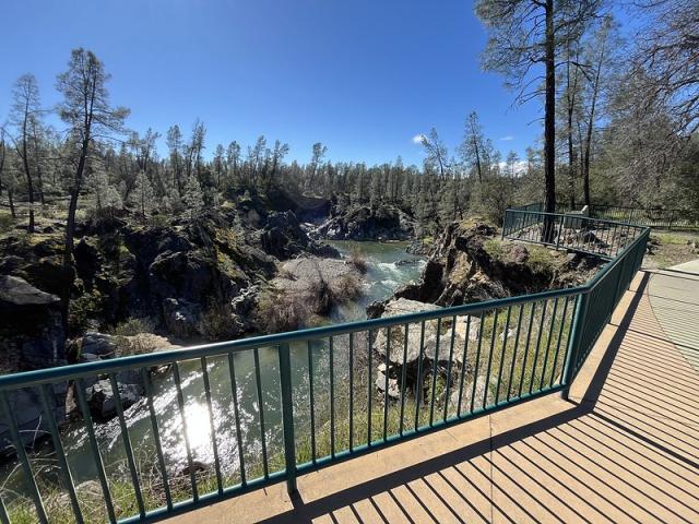
Continuing east on State Highway 299, just 15 minutes south of the town of Redding, you’ll find Clear Creek Greenway. This lovely scenic day use area is also managed by the Redding Field Office. A short, paved path leads from the parking lot to a pavilion with interpretive panels, and then onto an uncovered viewing platform where you can look down into the gorge to Clear Creek. If you’re lucky, you might even see salmon spawning! Covered and uncovered picnic tables can accommodate visitors in wheelchairs and benches provide plenty of seating for others.
Back on State Highway 299, continuing even farther east is the Pit River Campground, which, like Douglas City Campground, is open from May to October. The small campground, managed by the Applegate Field Office, has seven individual campsites, one group site, two accessible vault toilets, and an onsite camp host. This peaceful, scenic spot allows visitors with limited mobility to fish right at the water’s edge on a natural surface accessible fishing pier. The Pit River is famous for its wild rainbow trout.

Central California
Just 30 miles south of Sacramento off Interstate 5 is the Cosumnes River Preserve, managed by the BLM Mother Lode Field Office and six other partners. This 50,000-acre preserve has grasslands, vernal pools, wetlands, valley oak riparian forests, and lots of birds, with plenty of space to be immersed in calm and the music of nature.
The Preserve can be explored on four miles of trails. Detailed information and maps can be found on the Explore the Trails webpage. To encourage youth participation, a Kids’ Nature Trail Guide with space for nature journaling is available!
Scattered along the trails are numbered posts with QR codes. Scan the code to learn about the plants and other features of that stop. The Nature Trail Guide has a map with written information about each stop, which can be printed in advance.
Several other resources are available for visitors who like to learn about an area before venturing to new places, or for those who can’t physically be there but want to visit virtually. Learn about the different habitat types with the Interactive Habitat Map. Take a virtual Tour of Cosumnes River Preserve by selecting any or all of the 31 stops on the trails to see a photo of the stop and read the description in English or Spanish. Or watch the three five-minute videos to go on a virtual guided natural history hike.
The three-mile River Walk Trail can get completely flooded in the winter so it should only be accessed in dry weather. This dirt trail should only be attempted with an all-terrain wheelchair. The River Walk Trail loops around wetlands, the Cosumnes River, and oak savannah woodland. It offers the best opportunity for solitude the farther away from the parking lots you wander.
The out-and-back Boardwalk Trail and the Wetlands Walk Trail are both universally accessible. The wooden Boardwalk Trail is a half-mile round trip. It starts at the northern parking lot, meanders into the wetlands, and ends at a viewing platform. The Wetlands Walk Trail is a one-mile loop that can be accessed from the south parking lot near the Visitor Center or from the north parking lot by the Boardwalk Trail.

The Visitor Center, near stop 1 of the Wetlands Walk Trail, has displays and exhibits inside and accessible picnic tables outside on the deck and on the grass. There is also an accessible bottle-filling station on the deck.
South-Central California Coast
Piedras Blancas Light Station is part of the California Coastal National Monument and is managed by the Bakersfield Field Office. It sits on a rugged windswept point of land that juts into the Pacific Ocean. The lighthouse (light station) and some of the support buildings are listed on the National Register of Historic Places. Access to this historic site is by guided tour only, scheduled in advance. Most areas of the tour are accessible to people with limited mobility; however, there are stairs leading into and within the lighthouse.
It can be difficult for people with disabilities to make advance plans or to visit places with potential for bad weather or strong winds. The BLM and its partner, Piedras Blancas Light Station Association, have you covered. With just a computer, or smart phone or tablet, and an internet connection, anyone can take a virtual tour of the site.
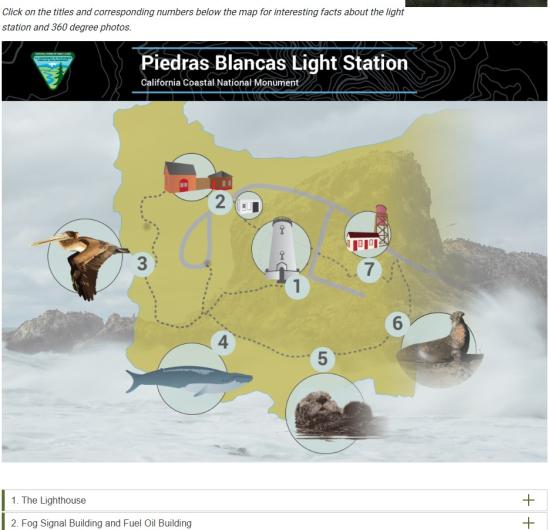
The virtual tour offers seven stops. Select each stop on the map to learn more and to see a 360-degree image of the location—it feels like you’re actually there! You can also take a virtual walk around the light station using the link to Google Street View, found on the Piedras Blancas Light Station webpage.
But that’s not all. There’s a short, one-minute video of elephant seals, including a baby and its mama. If you love the video (and who wouldn’t?!), there’s also a link to the Friends of the Elephant Seal Live Cam. This takes you to a page with two live cameras showing the Piedras Blancas Rookery, along with information about the elephant seals, rookery, weather, and tides.
Southern California
The Santa Rosa and San Jacinto Mountains National Monument near the town of Palm Springs in southern California is a nice place to visit when you’re looking for a break from overstimulation. Some of the trails and interpretive areas near the visitor center can provide a low sensory experience for neurodivergent visitors or others who can benefit from a low-noise area.
The National Monument encompasses 280,000 acres and is jointly managed by the BLM’s Palm Springs South-Coast Field Office and USDA Forest Service. It includes the San Jacinto and Santa Rosa wilderness areas, the Palm Canyon Creek Wild and Scenic River, and 280 miles of designated hiking trails, including several miles of the Pacific Crest National Scenic Trail. The Santa Rosa and San Jacinto Mountains National Monument Map & Guide can help you plan your trip.
Some of the trails, like the 1.2-mile Long Valley Loop Trail along Long Valley Creek, are reached by taking the Palm Springs Aerial Tramway to the Mountain Station. Although there is a concrete path from the Mountain Station down into Long Valley, the trail is quite steep, so it would not be accessible for most guests in wheelchairs.
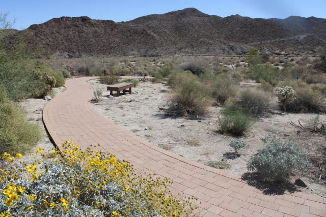
Consult the Santa Rosa and San Jacinto Mountains National Monument Palm Desert and Rancho Mirage Hiking Guide for information about 12 trails in the area, including the only universally accessible trail, the Ed Hastey Garden Trail. This 0.2-mile trail circles the Visitor Center in the town of Palm Desert and has signs identifying the common flora and fauna often seen at the lower elevations of the National Monument. The Visitor Center also has exhibits, books, and guides on the area’s indigenous and natural history.
Another way for visitors to explore the Ed Hastey Garden Trail (select Visitor Center drop down) is by solving challenges as a “secret agent,” using the Agents of Discovery augmented reality app. Borrego the Big Horn Sheep will be your Field Agent for these challenges. The app was developed to accommodate different learning styles and is available in six languages, so watch out for other secret agents in the area!
Fun Fact: The Garden Trail was named after the longest serving State Director of BLM California. Ed Hastey spent nearly 22 of his 40-year career leading BLM California from 1975-1979 and 1981-1999.
The final site we will talk about is the 1,200-mile Juan Bautista de Anza National Historic Trail, which starts in Sonora, Mexico, travels through Arizona and California, and ends in present day San Francisco. The Anza Trail Foundation webpage for this trail has driving routes, hiking and biking ideas, points of interest, resources, and maps for each of the five counties in Arizona and 14 counties in California. This information can help with trip planning, especially for neurodiverse visitors who benefit from knowing what to expect before traveling to new places.
You can also Explore the Trail virtually through an interactive map. Learn about the Anza expedition history by reading the actual camp diaries of Juan Bautista de Ana, Father Pedro Font, or Father Garcés between September 28, 1775, and April 8, 1776.
The part of the trail that goes through the Yuha Desert in southern California’s Imperial County has a cool feature. You can download a 21-minute audio tour, which describes sites shown on the BLM Routes of Travel for Western Imperial County, California brochure from the El Centro Field Office.

Voices on the audio portray a priest and Juan Bautista de Anza as well as the real voice of a Quechan (pronounced Kwatsáan) tribal elder, singer, and educator. These storytellers paint a picture of the geography, climate, history, and natural and cultural resources of the land along the journey. Audio stories can be beneficial to auditory learners and blind or low vision visitors.
These are only a few of the amazing areas the BLM manages in California on behalf of the American people. The BLM is dedicated to ensuring that everyone has an equitable opportunity to use their public lands by providing access to facilities, programs, services, and activities for people with disabilities. The BLM Accessibility Program provides details on opportunities, resources, laws, policies, and guidelines.
Useful Links
- EXPLORE Act – to improve recreation opportunities on, and facilitate greater access to, Federal public land.
- Access Pass – free lifetime pass for U.S. citizens or permanent residents with permanent disabilities.
- Military Lifetime Pass – free pass for Gold Star Families and Veterans.
- Every Kid Outdoors – free pass for fourth graders and their families.
Related Stories
- A day on patrol with BLM Arizona Ranger Rocco Jackson
- BLM California partners to secure America’s border
- BLM recreation sites available to all: Exploring accessibility on Arizona’s public lands
- Overcoming challenges to move the BLM forward: Nikki Haskett
- Steer clear of muddy roads and trails this spring
Office
2800 Cottage Way Suite W1623
Sacramento, CA 95825
United States