
Cottonwood Campground (El Centro)
Overview
Among the live oaks in southeastern San Diego County is Cottonwood Campground. The campground offers a tranquil and refreshing experience. Cottonwood Campground is an excellent starting point for day hikes, overnight backpacking trips, and equestrian use. The campground is located in the McCain Valley Resource Conservation Area.
A trail out of the campground leads to the Sombrero Peak Area, Upper Bow Willow Canyon, and Anza-Borrego Desert State Park. The Pepperwood Trail and Sombrero Peak Trail are both rated moderate to strenuous. The trails are sandy in composition and meander through public, state, and private lands. Elevations range from 3,000 to 4,500 feet.
This makes the area an excellent escape from the hot summer temperatures of lower elevations. Most precipitation is received from December through April. Thundershowers are common during July and August. Winter temperatures range from the 50s (F) to below freezing, with occasional snowfalls. Summer temperatures range from 60 to 95 degrees (F).

Cottonwood Campground is a year-round facility with 25 developed campsites. Fire rings, tables, and vault toilets are found in the campground. Horses are allowed only in the east loop of Cottonwood Campground. No group camping sites are available. No off highway vehicle (OHV) use is permitted in Cottonwood Campground or on McCain Valley Road. A $6.00 per campsite fee is required for camping at all BLM campsites.
All sites are available on a first come first served basis. Except for backpacking, all camping in McCain Valley must be in a designated campsite. A campfire permit may be required.
Accessibility Description (ABA/ADA)
The Campground is divided into an eastern and western section on either side of McCain Valley Road. Horse stables are available on the east side. They are about 10 yards off the access road, sitting on somewhat uneven terrain with scattered rocks and vegetation.
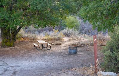
Cottonwood East and Cottonwood West have about 10 campsites each, with a relatively flat, natural surface loop connecting the individual sites. Each campsite has its own parking spur, with a similar natural surface. There is no cell phone service and no running water.
On each side of the Campground, an iron ranger fee-payment box sits on a concrete pad. The ground leading up to the payment box for Cottonwood East is likely to be more even than the box for Cottonwood West.
Each side of the Campground has 2 double-vault toilets. Because of inclines and uneven terrain with scattered rocks and vegetation, the toilets may be challenging to access for visitors using mobility devices. In addition, the road that connects the campsites to the toilets sometimes gets washed out by the rain.
On each side of the Campground, all the picnic tables at the campsites should be able to accommodate wheelchair users with extended table tops or inset legs. Each campsite has a fire ring with a grill attachment that is safe to use from a seated position. There are no picnic shelters at the site.
Note: Descriptions and photos uploaded February 2025. Please note that actual on-the-ground conditions may vary due to natural events (e.g., weather, wildfires, erosion), normal wear and tear, or site improvements.

Phone
Geographic Coordinates
Directions
From Interstate 8, take the Boulevard exit. Proceed south to the first stop sign. Turn left/east on Old Highway 80. After approximately 2 miles, turn left on McCain Valley Road. A sign with mileage information is located at the junction of McCain Valley Road and the road to Sacatone overlook.