Sand to Snow National Monument
Remember your OUTDOOR ETHICS when enjoying your public lands. Please RECREATE RESPONSIBLY.
Overview
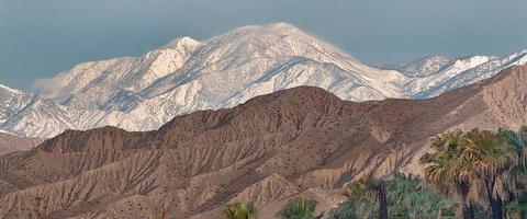
Encompassing 154,000 acres, including just over 100,000 acres of already congressionally designated Wilderness, Sand to Snow National Monument is an ecological and cultural treasure and one of the most biodiverse areas in southern California, supporting more than 240 species of birds and twelve threatened and endangered wildlife species. Home to the region's tallest alpine mountain that rises from the floor of the Sonoran Desert, the monument also will protect sacred, archaeological and cultural sites, including an estimated 1,700 Native American petroglyphs. Featuring thirty miles of the world-famous Pacific Crest National Scenic Trail, the area is a favorite for camping, hiking, hunting, horseback riding, photography, wildlife viewing, and even skiing.
Know Before You Go
Sacred Heritage
The Serrano and Cahuilla Indian people lived at the base of San Gorgonio Mountain and considered it a sacred place. The Mountain provided food, medicinal plants, basket making material, deer and other animals to hunt. San Gorgonio Pass served as a major trade route from Arizona to the California coast.
Recreation
The 11,500-foot San Gorgonio Mountain rises sharply from the Sonoran Desert floor and is the highest peak in California south of the Sierra Nevada Mountain Range. The Monument includes 30 miles of the 2,600-mile Pacific Crest Trail, and visitors can enjoy, hiking, camping, backpacking, climbing, horseback riding, hunting, fishing, stargazing, mountain biking, photography, wildlife viewing, cross country skiing, and solitude. A series of preserves owned by the Wildlands Conservancy are managed for public access and serve as entry points from the north, south, and east of the Monument.
Camping
Campfire permits are required and may be restricted during fire season. Fire danger is extreme for most of the year. Campfire permits can be obtained online at www.preventwildfireca.org. To learn more about the do's and don’ts for dispersed camping please visit www.blm.gov/camping.
Off-Highway-Vehicles
The Sand to Snow National Monument encompasses more than 100,000 acres of Congressionally designated wilderness and is closed to all motorized vehicles including off-highway vehicles, all-terrain vehicles, motorboats, motorized equipment, bicycles, motorcycles, hang gliders, wagons, carts, and portage.
Helpful Links
- Download the Sand to Snow National Monument Information Guide
- More Information: Sand to Snow National Monument
Photos
Phone
Activities
Addresses
Geographic Coordinates
Directions
The sandy part of Sand to Snow is accessible at the Whitewater Canyon Preserve area within the monument - the turnoff for Whitewater Canyon is five miles west of Palm Springs on Interstate 10. Take Whitewater Canyon Road five miles north to the trailhead. To visit the snowy parts go to Forest Falls and a short hike on the Vivian Creek Trail. To reach the trailhead, continue west on I-10; take the exit to Yucaipa and follow State Highway 38 north, then east to Forest Falls.


