
Case Mountain Extensive Recreation Management Area
Overview
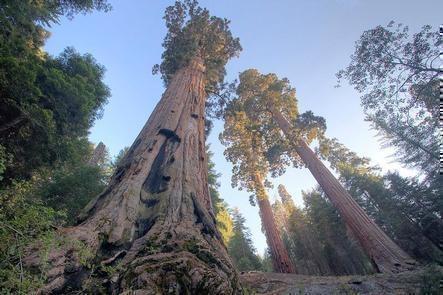
Nestled in the heart of the Sierra Nevada foothills, Case Mountain offers a stunning natural escape for outdoor enthusiasts. Also known as Salt Creek to many locals, the Recreation area has miles of Non Motorized trails that wind through oak woodlands, chaparral, and scenic ridgelines.Case Mountain Extensive Recreation Management Area (ERMA) contains the only Giant Sequoia Grove complex managed by the Bureau of Land Management. The complex is comprised of six distinct sequoia grove units, which total about 444 acres. Whether you're seeking a peaceful stroll or an activity with more challenging terrain, there is something here for every skill level. Adventurers can enjoy breathtaking views of the surrounding Sierra Nevada peaks and the Tule River Valley. The area's rich flora and fauna make it an ideal spot for photography, birdwatching, and connecting with nature. From the upper elevations, visitors are treated to panoramic vistas and sweeping views. Case Mountain is accessible and enjoyable year-round, with different seasons offering unique experiences. Be advised of all weather conditions and prepare accordingly. All public access to Case Mountain ERMA is non-motorized.
Recreation Opportunities
- Biking - On designated trails, this area is a popular spot for downhill mountain biking
- Wildlife/Scenic Viewing & Photography - Enjoy the natural beauty of the landscape and the critters that inhabit it
- Horseback Riding - Trailer staging is located at the Craig Ranch parking lot
- Fishing and Hunting - With valid licenses and in compliance with state and local regulations
- Camping - Dispersed camping is permitted past a 3/4 mile radius from the trailhead (see map)
Facilities Description
Trail Heads begin at the terminus of Craig Ranch Road and Skyline Drive.
Popular Trails
Skyline Trail (Lower Loop)
- Distance: 2 mi (3.5 km)
- Time: 1 hour
- Elevation Gain: 300 ft (100 m)
- Difficulty: Easy
A lower elevation hike that is short and scenic. The popular loop offers great views of the surrounding
landscapes with charming bridges over the creek and many places to stop for a picnic.This trail is
perfect for a leisurely hike and a great escape for all skill levels.
Salt Creek Falls (Lower Waterfall)
- Distance: 4.5 mi
- Time: 2 hours
- Elevation Gain: 800 ft
- Difficulty: Moderate
Follows Craig Ranch Road for a portion of the way and cuts down and across the valley at the lower waterfall.
This hike is for experienced hikers due to steep grades on the southern portion. Please be aware of bikes and
other users on the trail, especially as it narrows to single-track.
Salt Creek Falls (Upper Waterfall)
- Distance: 6 mi
- Time: 3 hours
- Elevation Gain: 1500 ft
- Difficulty: Strenuous
Similar to the lower waterfall, this hike continues up to Holland Corral for beautiful panoramic views of the valley. It
is longer than the lower falls and a higher elevation climb, so take caution with steep grades and carry water.
Additional Information
- Parking area hours are from 6am to 8pm daily
- SPEED LIMIT 15 MPH, Craig Ranch Road and Skyline Drive are residential areas
- Overnight camping prohibited in Twin Ponds
- Overnight parking prohibited
- Motorized Use prohibited
Photos

Phone
Activities


Geographic Coordinates
Directions
Head East on HWY 198 approx. 2 miles from the Three Rivers Historical Museum, just past an old stone bridge.
Turn right on to Craig Ranch Road (the turnoff for St. Anthony's Retreat).
Follow the road to the right through telephone poles for about 1 mile.
OR
Turn right on Skyline Drive (at the corner of Three Rivers Memorial Building). Follow the road for about a mile.
Respect private property -- do not park on residential streets, block driveways, or speed on Skyline drive.