
Free mapping program to help Americans navigate BLM public lands
Organization:
Media Contact:
WASHINGTON - There’s a new tool for recreationists planning visits to public lands. The Free National Mobile Map Package Program allows anyone to access maps so they have the information they need to get outside, even when they are offline.
BLM’s Enterprise Geospatial Services Team is developing these maps for 18 western U.S. states. The project will later expand to include all 50 states and, potentially, U.S. territories.
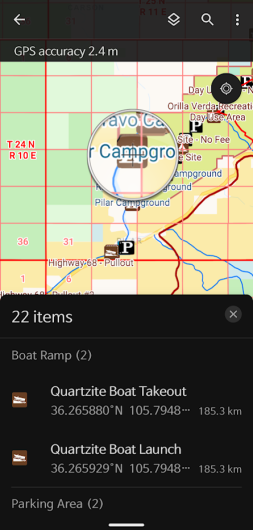
Existing datasets include information about who manages areas of land, what recreation and other opportunities are available, roads, streams, lakes, and other natural landmarks. The team will export updated versions of these datasets quarterly to ensure users can access the most up to date information possible.
To access the free maps, download the ArcGIS Field Maps app from the app store on your Apple or Android device. After opening the app, you don’t need an account so skip sign-in, then search for “BLM MMPK” and download the state maps you would like to access offline.
For more detailed instructions on how to use this program and to find answers to commonly asked questions, visit the program’s website on blm.gov.
The BLM manages about 245 million acres of public land located primarily in 12 western states, including Alaska, on behalf of the American people. The BLM also administers 700 million acres of sub-surface mineral estate throughout the nation. Our mission is to sustain the health, diversity, and productivity of America’s public lands for the use and enjoyment of present and future generations.