
Fairbank Historic Townsite | Arizona
Fairbank is a "ghost town" located within the San Pedro Riparian National Conservation Area (SPRNCA), along the San Pedro River. It was founded in 1882 when a railroad station was built here.
Its life as a town began with the construction of a railroad in 1881, and it soon became an important depot as well as the closest railroad stop to Tombstone, then one of the largest western cities (15,000 in 1882). Originally called Junction City, Kendall, then Fairbank, it was officially named Fairbank on May 16, 1883. The name refers to N.K. Fairbank of Chicago, who helped finance the railroad
The town was built on an old Mexican land grant, the San Juan de las Boquillas y Nogales, which was bought by the Boquillas Land and Cattle Company in 1901. The company evicted all potential landowners, but continued to lease the mercantile building and a few residences well into the 1970's. The Bureau of Land Management acquired the land that was once the Mexican Land Grant in 1986 as part of the San Pedro Riparian National Conservation Area.
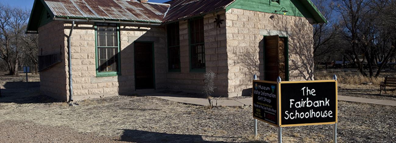
Today, this area includes the Fairbank Trailhead with parking for cars and trailer vehicles, a Visitor Contact Station in the historic Fairbank School House, operated by the Friends of San Pedro River and several historic buildings along the historic Railroad Avenue including the Mercantile Building which operated until the early 1970s. Near Fairbank is the San Pedro River and beautiful examples of riparian and mesquite woodland, as well as the historic Fairbank Cemetery, and the historic Grand Central Mill north of town. The Fairbank historic town and San Pedro River corridor became part of the NCA in 1998.
The area is open for the public to enjoy. There is an interpretive trail in the townsite and a visitor center and museum in the historic schoolhouse. Take a self-guided tour around what was once a thriving boomtown of the wild west!
Be on the look-out for historical points of interest. But note: It is illegal to remove any historic artifacts from public lands. Please leave everything in its place. Thank you for your help in preserving our historic resources! The use of metal detectors is prohibited.
While you explore the Fairbank Historic Townsite, you may encounter birders, walkers, bicyclers, equestrians, dog walkers, and backpackers.
A Junior Ranger book introduces young adventurers to the lands and resources managed by the Bureau of Land Management, including the SPRNCA.
Hours and Seasons
The Schoolhouse Museum is staffed by the Friends of the San Pedro River. It is open Friday, Saturday, and Sunday, plus Monday holidays. It is open from 9:30 a.m. to 4:30 p.m. The parking area is open from sunrise to sunset. The volunteer staff can provide you with information about Fairbank and the history of the area. Museum exhibits contain artifacts, photos, and information about the people that lived here in the Territorial days.
Features and Services
- Drinking Water: Visitors should bring their own water and bring plenty for hiking in this area.
- Toilets: There is a toilet at the trailhead as well as at Miller Backcountry Camp and the San Pedro House along the San Pedro Trail.
- Cell Phone and Internet: Cell phone reception can be spotty during bad weather, but generally the service is good. Public internet/Wi-Fi is not available.
- Pets: Pets are generally allowed in the SPRNCA but must be kept on a leash at all times in developed areas, including trailheads, interpretive sites, and locations near the two visitor contact stations. Please pack out any pet waste.
Safety and Conditions
You are responsible for your own safety. Call 911 to contact local law enforcement, obtain emergency services, or report a fire.
While enjoying your visit, keep in mind that there is no first aid available on-site. The nearest hospital is in Sierra Vista.
The San Pedro River is subject to seasonal flooding, and summer monsoons are common.
The region is a travel corridor for illegal immigrants traveling from Mexico. Nevertheless, visitors can safely enjoy the San Pedro National Conservation Area. Please report all suspected illegal activities to the Bureau of Land Management or local law enforcement authorities. Avoiding contact with people exhibiting suspicious behavior or engaged in dangerous activities.
Respect and Protect
Please remember to practice outdoor ethics and recreate responsibly. Help us protect this unique environment by staying on designated motorized routes, observing wildlife from a distance, and leaving no trace during your visit.
Vegetation, archaeological, historical, and paleontological sites and artifacts are protected by federal law. It is illegal to damage, destroy or remove any artifacts or structures.
Check for fire restrictions before your visit. Using exploding targets, fireworks, sky lanterns, tracer ammunition and other incendiary devices is prohibited on BLM-managed public land in Arizona.
Accessibility Description (ABA/ADA)
View images of accessibility features in a new window.
Cell phone reception at Fairbank Historic Townsite can be spotty during bad weather, but generally the service is good.
Townsite. A general parking area with packed gravel is located to the east of the townsite and has room for about a dozen vehicles. A hardened trail leads from this lot to the townsite. Closer to the townsite there are 2 concrete parking spaces for accessible parking only, with an access aisle between them to accommodate vans.
An accessible single vault toilet sits on a concrete pad near the accessible parking spaces.
A concrete path runs from the accessible parking spots to the schoolhouse building, an accessible living interpretive site open Friday – Sunday. The schoolhouse has interpretive panels and large flip books about the history of the site and the surrounding area.
The other buildings at the townsite are closed to the public, but there are interpretive signs explaining the buildings’ history and functions scattered across the site.
Picnic area. Approximately 6 uncovered picnic tables sit on natural ground in an area shaded by trees. The tables were not designed with accessibility in mind, but there is an accessible fire ring with grill attachment for safe use at sitting height.
Next to schoolhouse is a larger group picnic site that’s also shaded by trees. This site has several picnic tables with inset legs and an oversized pedestal grill all sitting on a large concrete pad.
Trail. A hardened, 1.25-mile trail of compacted gravel leads to the old mill to the north of the townsite. This trail is relatively flat, with a grade of less than 2 percent.
Descriptions and photos uploaded February 2025. Please note that actual on-the-ground conditions may vary due to natural events (e.g., weather, wildfires, erosion), normal wear and tear, or site improvements.
Flickr Album

Contact Us

Activities


Addresses
Geographic Coordinates
Directions
A four-wheel-drive or high-clearance vehicle is not required to access the Fairbank Historic Townsite.
From Tucson, follow I-10 E to AZ-90 S in Benson. Take exit 302 from I-10 E. Follow AZ-90 S and take AZ-82 E to Fairbank Historic Townsite. From Sierra Vista, follow AZ-90 N and take AZ-82 E to Fairbank Historic Townsite.
The parking area is on the north side of the highway, .5 miles east of the San Pedro River. It is addressable as Fairbank Townsite in map apps.
A general parking area with packed gravel is located to the east of the townsite and has room for about a dozen vehicles, with space for trailer parking.
You can get food and supplies in these nearby communities: Sierra Vista, Tombstone, Whetstone, Bisbee, Hereford and Palominas. Nearby public lands include the Coronado National Memorial and the Coronado National Forest.
Fees
It is free (no fee required) for the general public to visit the Fairbank Historic Townsite. Day use throughout the San Pedro Riparian National Conservation Area is free; you don't need a permit.
You must have a permit for overnight backcountry camping. Permit fees are $2 per person per night. You may have a campfire only in designated areas. Camping is limited to seven consecutive nights within any period of 21 consecutive days in any one location, unless otherwise authorized.
Water is not available on site. Please pack enough for your visit.
Commercial operators must secure special authorization prior to their planned visit.
Stay Limit
Backcountry camping in the San Pedro Riparian National Conservation Area is allowed 1/2-mile away from any public access point. Dispersed camping is usually found further up on the Fairbank Loop Trail, 1.5 -2 miles north of the Townsite. Camping is limited to seven consecutive nights in any one location, unless otherwise authorized.