
Sentinel Landscapes initiative in Arizona brings agencies and landowners together on common goals
Listen
Subscribe
Related Content
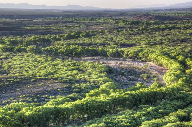
The Sky Islands of southeastern Arizona are a bowl-like natural feature that blocks out many electromagnetic signals. This is an ideal environment for the Department of Defense to train intelligence specialists and drone operators. It's also part of a unique ecosystem that includes millions of acres of BLM, Forest Service, State of Arizona, and private lands that all involved would like to see conserved. In this episode of "On The Ground," we visit with BLM Gila District Manager Scott Feldhausen on how he has brought BLM to the conversation with other agencies to accomplish restoration on parts of the three million-acre Sentinel Landscape area.
Transcript
DAVID HOWELL, Host and Senior Communications Specialist: Public lands managed by the Bureau of Land Management are frequently interspersed with lands owned by private land owners or other public agencies. This includes our nation’s military bases, many of which have land management goals of their own.
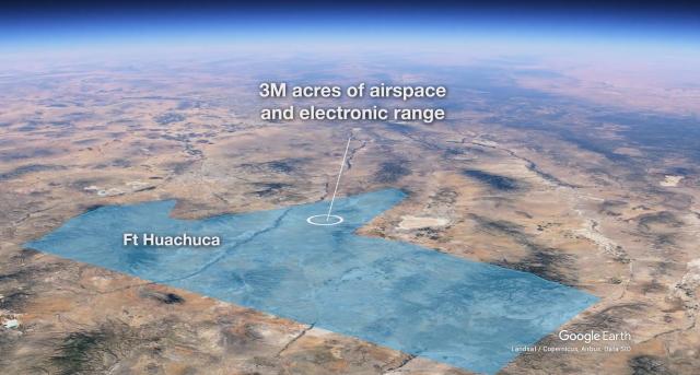
I'm David Howell, and you're listening to “On The Ground, A Bureau of Land Management Podcast.” Near Tucson, Arizona is the 200,000-acre Fort Huachuca, an Army base located in the Sky Islands, a mountainous area between Tucson and the Mexican border. The Sky Islands area is also managed by BLM, the U.S. Forest Service, other public agencies and many private landowners.
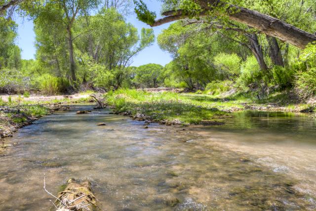
Scott Feldhausen has been the BLM Gila District Manager and has been working with the Department of the Army on their Sentinel Landscapes program, which is an agreement for Land Management between the Army, the Department of the Interior, and the Department of Agriculture. In 2023, BLM designated land in the Sky Islands as one of its restoration landscape areas, investing hundreds of thousands of dollars from the Inflation Reduction Act toward restoring public lands in the San Pedro Riparian and Las Cienegas National Conservation Areas. And Scott said that this investment fits really well with the Sentinel Landscapes.
SCOTT FELDHAUSEN (BLM Gila District Manager): And the purpose of it was to sustain the area’s vital ecosystems, support compatible land uses, foster community partnerships, leverage collective resources, because nobody has everything they need to get the job done…
HOWELL: Right?
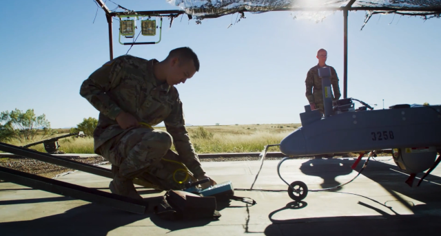
FELDHAUSEN: …All while ensuring the continued viability of the very unique testing and training mission at Fort Huachuca. Most of the focus for them is as an electronics warfare testing and training mission. It is where the Army Corps intelligence officers are trained and is where all Army and Marine UAV drone operators are trained.
HOWELL: Okay.
FELDHAUSEN: So, it is mostly focused on how to know what the enemy is doing, and while keeping our military safe.
HOWELL: We've got some fairly unique and sensitive areas in that area that we're trying to protect. So, what's the relationship then between the Fort Huachuca operation and what you want to accomplish out on BLM?
FELDHAUSEN: There are really four pillars to what we're doing on the military resilience, and Fort operations is one of them. Endangered species conservation protection/restoration actions is another. Water conservation, particularly tied to the San Pedro River and the San Pedro Riparian National Conservation Area is a third. And then, keeping working lands working, keeping those open landscapes in that traditional rural economy so that you don't have development pressure from a bunch of residents or infrastructure from cell towers, power lines, that type of stuff which would conflict with the military mission.
And so, it's -- when you look at the Fort Huachuca mission of “a flexible testing and training community that conducts successful missions at Fort Huachuca, in partnership with a vibrant rural economy, preserving protected ecosystems, conserving natural resources, and building resilience across the landscape,” that aligns very easily with BLM's mission of “to sustain the health, diversity, and productivity of America's lands for the use and enjoyment of present and future generations.”
HOWELL: Right.
FELDHAUSEN: The challenge has been trying to understand “what the Department of Defense needs where” so the federal partners such as BLM can…not do something different than we would otherwise, but potentially shift “what we're doing where.” So if I have funding to do a landscape restoration or vegetation treatment, I could do it anywhere on the 2.3 million acres in the Gila District, but if I can do it right next to where NRCS provided funding to a private rancher to treat his 5,000 acres, and on the other side of where the Fort has done treatment on their lands, then we're actually having a landscape level effect rather than doing things in postage stamps around the land[scape]. Nothing we're doing precludes the individual partners from doing their own work. It just helps guide what we do and where.
Another example of how it's benefited is, you know, trying to reduce development pressure in key flight paths -- that aligns on the southern end of the La Cienegas National Conservation Area, which also has a tributary that drains into the San Pedro River. And so, the fort's providing funding to establish conservation easements along that area has increased, essentially, the protected area that we have within the Las Cienegas National Conservation Area, and protected a wildlife migration corridor between the two Sky Islands on either side.
HOWELL: So from a land perspective, and I guess even from a conversation perspective -- not conservation, conversation perspective – is BLM kind of the “glue” that's pulling a lot of these efforts together? I mean, you and I have talked years ago in the past when we were both in Idaho, you know, how BLM is between the private land/between the Forest Service, in that case. In this case, you probably find yourself in much the same situation between a lot of disparate interests. Are you part of that central conversation to bring everybody together for restoration projects?
FELDHAUSEN: Yes, for sure. Yeah. The landscape down here is a very intermingled landscape. The Sentinel landscape is about 1/3 Federal, between Department of Defense, Department of Ag [Agriculture], and Department of Interior; about 1/3 private; and 1/3 state [land]. The Forest Service has typically the higher elevations in the Sky Islands. The BLM has scattered, intermingled areas across it, as well as the two conservation areas. And so it's critical to work together. Traditionally, we only get “forced to do it” that way when it comes to wildfire because a fire crosses everybody's land when it gets going.
HOWELL: That's right!
FELDHAUSEN: This, the Sentinel Landscape effort -- because we use a shared leadership model, it really focuses a conversation about what we're each doing, where we're doing it, why we're doing it and where the opportunities are to align more effectively.
So, for example -- and I was working very closely with the communities down in Sierra Vista on impacts to groundwater, to the San Pedro River, [San Pedro] Riparian National Conservation Area when the Sentinel Landscape Coordinator was able to connect the dots between what we're doing and potential funding sources DoD has. That really shifted the conversation about how we could approach management in the future.
That sharing of knowledge really allows us to connect dots. The Forest Service through their wildfire crisis effort has been really focused on doing a lot of landscape treatments and fire modeling in the Sky Islands, but it was just there. Now we have USGS at the table looking at wildfire modeling and resilience across the landscape, connecting with what the Fort’s doing around their installation, with what the Forest Service is doing up on the mountain tops, with what the BLM could do down along the San Pedro. And interesting things are coming out of it! In some of that modeling, we're learning that the mountain front recharge -- the precipitation going in the ground along the foothills of the mountains -- is very, very critical to groundwater recharge in the San Pedro River Basin. Does that information help us align with the Forest Service and the Fort and the communities are going to do their fuel treatment? It certainly does. And so, now we can incorporate “what if we shift from doing it here to here” and to the groundwater model, and tell us what the effect is. It's not changing what we're doing; it might change where we do it.
HOWELL: What do you see, as forecasting for the future, major projects or, you know, major initiatives that you want to see keep going?
FELDHAUSEN: Yeah, yeah -- We're wrapping up our brand new strategic and comprehensive plan right now that kind of combines everything we've done in the past and sets the standard for the future. The two big initiatives we have right now are fully creating an integrated groundwater-surface water model, which will help us evaluate both the impact of a changing climate on the health of the San Pedro River, as well as what the current and proposed restoration projects have on that.
Same time, we're also building out, or the beginning stages of building out, a comprehensive fire modeling tool for the landscape so that we can look at both “values at risk” as well as the impact of vegetation treatments to reduce fuel loads across the landscape, and better focus them -- not just on federal lands where we have a focus, but across that landscape to really, truly protect, as best we can, the most important ecological areas.
HOWELL: Well, great! This has been wonderful, Scott. Thank you so much for visiting with me on this.
FELDHAUSEN: Yeah. Thank you, Dave. It's been a pleasure working on this project. It's one of those things that you that really brings joy! It really, you know -- implementing BLM’s mission across the landscape with multiple partners in a way that we would normally never get to, on private lands, on state lands, on other federal lands, and helping everybody else succeed, too? That's the fun part of the job!
HOWELL: Scott Feldhausen is the Gila District Manager based out of Tucson, Arizona. We'll have more information on our website for this episode, including a link to the SentinelLandscapes.org site for Fort Huachuca. There is a very good documentary there about the landscape and interviews with Scott and other leaders speaking about the goals of the program.
We're coming up on the end of season 1 very soon for this “On The Ground” podcast, which you can find on iTunes and Apple Podcasts, and on BLM's website: BLM.gov/media/podcasts.
I'm David Howell, thanks for joining me! And we'll see you out there, “On The Ground.”