
Unleashing the Science - Cadastral Classroom Investigation Field Exercise
It might be a challenge to declare the coolest science job in 2024 – however, we bet that 13 Idaho homeschoolers and their parents would tell you that it’s Cadastral Surveying – hands down.
When you love the outdoors, probably the worst thing about adulting is being stuck behind a desk, right? Well, according to Monte King, Bureau of Land Management Idaho supervisory cadastral surveyor, you don’t have to. You can be outside! And he often is…
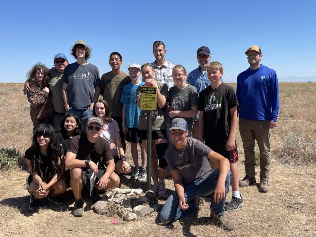
On June 10, the Excelsior homeschool group of Nampa, Idaho, and the Idaho Bureau of Land Management cadastral staff participated in a cadastral classroom investigation field exercise, demonstrating how science in the field can be fun.
Here’s two tips to make science fun:
- Get your hands dirty!
- Take field trips and explore with the Idaho Bureau of Land Management cadastral team!
What makes cadastral different than other surveyors? They are boundary experts who create, mark, retrace, and reestablish BLM and other federal land boundaries.
How does science fit into this?
“Science plays a huge role in surveying. We investigate, examine evidence, identify rocks and trees in decayed state, use dendrology, geodesy, botany, aerial photography, and geospatial positioning (GPS),” says Monte. “We’re a Jack of all trades – especially science trades.”
If you don’t understand, don’t worry. I had to have it explained too.
Dendrology is the study of woody plants. The cadastral team must be able to identify trees and even rotten wood, that might smell like turpentine if it is pine. Pioneering surveyors used bearing trees and wooden stakes and markers to monument “corners” or points that determine boundaries.
Bearing trees are trees surveyors notched, blazed, and scribed in a standard way to facilitate relocation of a corner should the wooden corner post or corner stone be lost or moved.
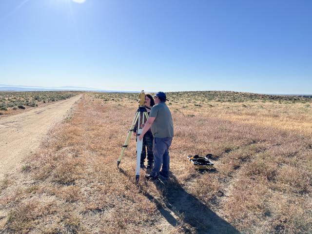
Since boundaries include rivers, cliff edges, other natural features and are often weird geometric shapes and not straight lines, surveyors use different tools and math, such as GPS and triangulation/trigonometry, to calculate the boundaries.
The story of cadastral surveying started with 66-foot-long chains, which surveyors carried to the location they were surveying. The old surveyors couldn't chain across a river. They applied triangulation. Today technology and new equipment play a role in finding the location they are scouting.
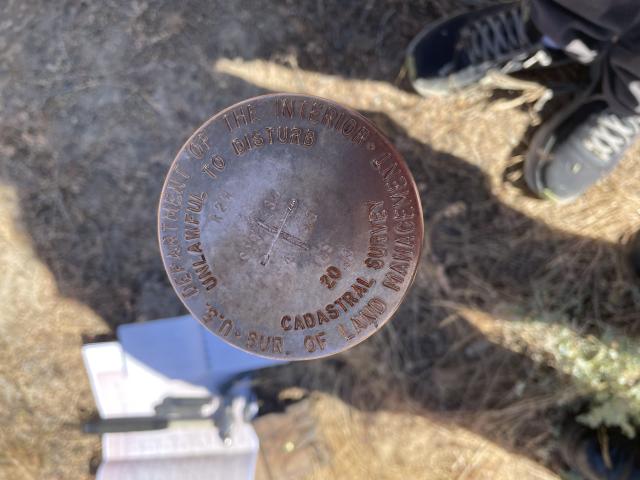
“One problem we are trying to stem is that corners are lost during climate change and natural processes. They are often lost during wildfires, landslides, flooding, or hurricanes. We try to execute new surveys or perform monument protection and replace decaying and disturbed monuments with modern metal monuments. Even if the modern monuments are disturbed, the new surveys, which rely on more precise measurements using GPS and other modern measurement tools, are recorded and more accurate than the original surveys, which used chains to calculate measurement,” said Monte.
If Cadastral doesn’t resurvey and/or protect the monuments, it could cost hundreds of thousands of dollars to reestablish boundaries.
“Digging is a big part of surveying, looking for corners and evidence that previous surveyors marked,” said Monte. “Surveying, where you get paid to play in the dirt!”
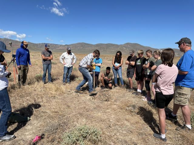
The day the Excelsior homeschoolers (ranging from middle school to recent high school graduates) hung out with the cadastral team, they went home dirty. They re-monumented an original 1894 stone. The students were tasked with finding the stone using GPS and approximate Geographic Coordinate Data Base (GCDB) coordinates (latitude and longitude). They installed a metal marker, which is easier to see and helps protect it from disturbance. They also help wildland fire crews know what to avoid when they might be fighting fire in the area.
The students watched demonstrations of equipment and original survey evidence (1870s General Land Office (GLO) wood posts, 1890 GLO wood post, and a 1923 bearing tree blaze from a timber companies' surveyor).
“We were given notes from the original surveyors, a compass, a GPS with a six-foot tripod and a beacon and were tasked with finding the monument - a pile of rocks two-feet wide by six-inches high,” said homeschool student Clayton Costa, age 14, who explained how he and the other students moved North and West by degrees and feet until they found the monument. “This was the first time I used a compass since I’ve never been lost in the woods.”
Surveying also includes tomes of research and documentation. Monte has used aerial imagery produced by drones, old pictures from magazines or newspapers, documents in National and state archives. Ultimately, the cadastral team will produce a set of official notes to document the re-monumentation, to include listing the students’ names on the assistant page.
“It will be an awesome memento for them!” said Monte. “When can I hire this kid?” Monte asked, after watching the homeschool students eagerly looking through the Total Station and using GPS to ‘stakeout’ the corner and begin to dig to set the monument.
"I am more interested in live science, but seeing what my dad does for work was really cool!” said Monte’s daughter Ashlyn King. “Hearing his stories is one thing, but seeing it and participating helped me better understand Cadastral land surveying."
It’s not difficult to see what attracts people to this profession. It’s the adventure/outdoors. “Hook, line and sinker…” that drew Monte to the Cadastral career field. He’s worked in 17 states, four separate BLM state offices. “If you don’t like the outdoors and don’t like adventure, this is not the job for you.” With a slogan like that, why wouldn’t we introduce our kids to this type of work?
You could rank up there with some of America’s most famous surveyors, presidents George Washington, Abraham Lincoln, and Thomas Jefferson and Lewis and Clark. If you are thinking of becoming a land surveyor, or are interested in the field, BLM land surveyors can facilitate hands on field trips.
“This fieldtrip is a great introduction to BLM,” said Costa, who has an interest in wildlife biology and putting tracking collars on animals. “I didn’t know anything about surveying during the trip I got offered a position, if I’m interested when I’m old enough to join.”
When students study algebra, they often ask, when am I ever going to solve for X in real life? Here is one career where math and science are used in real life every day!
The classroom investigation guide, written by the cadastral team is an educational resource for teachers to explain how math and science are used in real life. The link is here: Classroom Investigation Cadastral Survey.
This story is part of the “Unleashing the Science” series, showcasing how bureaus within the Department of the Interior produce and apply science to ensure responsible management decisions for our planet now and for the future.
Related Stories
- Bradley Dillon: The Man Who Measures America
- Restoration crews are racing against time
- Tracing freedom’s lines: How a BLM surveyor honors America’s 250-year legacy
- Joining forces to clear the way: Fire and aviation crews from Idaho and Nevada assist in Southeast storm relief
- Owyhee Field Office and partners collaborate to improve sage grouse habitat