Cleveland Tailings
| BLM District | Spokane (Washington) | BLM Field Office | |
| Congressional District | Washington 5th | AMLIS # | WA135800002 |
| State Office Contact | HUC # /Subbasin | 170103070603 | |
| Field Office Contact | Specific Watershed | Franklin D. Roosevelt Lake | |
| Location | Township 40 N., Range 25 E., Sections 14 and 23, Township 30 N., Range 38 E, Section 9, in the northwestern corner of the section. Latitude - 48 07' 10.508" north, Longitude - 118 02' 14.142" west | ||
| Land Ownership | About 96% public domain (BLM) and 4% private: total of about 2.57 acres. | ||
| Estimated Cost | |||
| Other Agency Links | |||
| Google Earth | |||
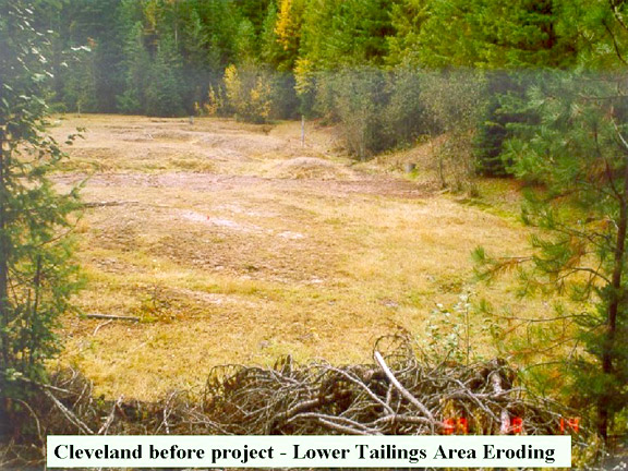
A branch of Hunters Creek flowed across the tailings areas and downstream to Franklin D. Roosevelt Lake. A former tailings impoundment had been breached and hazardous materials were eroding into the stream. The site is adjacent to an existing road and has been used by recreational visitors. There are also residences and an informal camping area on private lands downstream.
Activity at this site may date back as early as 1892. The Cleveland Mine and mill were developed in northeastern Washington in the Huckleberry Mountains in the Deer Trail Mining District. The site is located about 40 miles northwest of Spokane, WA, and eight miles due east of the town of Hunters, WA, in Stevens County. The mine and mill began operations in approximately 1917, and both were located on private land (patented claims) at the head of Hunters Creek. Two tailings impoundments were developed at downstream locations on public land. Activities at the mine appear to have continued until at least the late 1960s. The mine has been inactive since 1972. In 1995, a BLM abandoned mines investigation started evaluating these tailings sites. The upstream site (about 0.4 acres) is entirely on BLM-managed public lands. The downstream site (about 2.17 acres) is about 95% on BLM-public land and extends a short distance onto private land. A branch of Hunters Creek previously ran directly across both sites. Both old impoundments had failed and the stream was eroding tailings. BLM's site characterization found elevated levels of several metals in the tailings, including arsenic, cadmium, lead, and zinc. The BLM conducted a removal-site evaluation and prepared an Engineering Evaluation/Cost Analysis in 1998, in consultation with the Washington Department of Ecology, to evaluate corrective measures which the BLM then initiated. The tailings sites were consolidated, capped, and developed into onsite repositories in 1999-2000 and the stream was relocated away from the tailings. The BLM is continuing site clean-up operations.